
Portions of the 100th Legislative District are experiencing rising flood waters along the Mississippi and Illinois Rivers. The State of Illinois is working to inform the public of road closures and flooding along public trails.
Our crews delivered 375 tons of sand & 50,000 sandbags today to help with #flood fighting efforts throughout IL. pic.twitter.com/iwtheYyNEK
— IDOT (@IDOT_Illinois) June 30, 2015
Illinois #River: Closed to all vessels between MM 30-89. Recreational vessels prohibited from MM 0-187.
— IDOT (@IDOT_Illinois) June 29, 2015
Numerous road closures due to flooding. Here is a listing of which roads are closed: http://t.co/bebyEWL31U #ilwx #ILtraffic
— IDOT (@IDOT_Illinois) June 29, 2015
The Sam Vadalabene Great River Road Bike Trail between Alton and Grafton is flooded. Please consider alternate trails. #ILtraffic
— IDOT District 8 (@IDOTDistrict8) June 29, 2015
IL Route 100 in Alton is closed. Please follow detour. #ILtraffic
— IDOT District 8 (@IDOTDistrict8) June 29, 2015
IL Route 3 in Grafton will close @ 7:30 pm Sat. – effectively closing the main intersection in Grafton. Follow marked detours. #ILTraffic
— IDOT District 8 (@IDOTDistrict8) June 27, 2015
IL 100 between IL 3 in Grafton & IL 16 north of Nutwood is closing due to rising floodwaters. Please follow the marked detour. #ILTraffic
— IDOT District 8 (@IDOTDistrict8) June 26, 2015
Illinois Route 100 between Kampsville and Hardin is closed due to rising floodwaters. #ILTraffic
— IDOT District 8 (@IDOTDistrict8) June 26, 2015
A full list of road closures can be found at the IL Department of Transportation’s website.
Also, the National Weather Service is tracking the Illinois River at Meredosia. The river is predicted to crest July 2nd. You can monitor the Illinois River flood stages at the National Weather Service’s website.
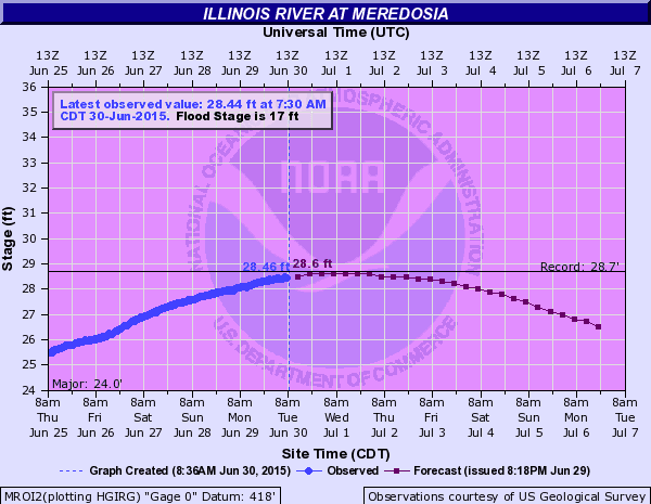 |
| Illinois River at Meredosia, June 30, 7:30am (CDT). Source: National Weather Service |